View / Download Karnataka NRDMS Brochure


 Natural Resources Data Management System (NRDMS)

Introduction

Vision

Genesis of NRDMS

Need of NRDMS

Objectives

Methodology

GIS

District NRDMS

Geospatial Database

Major outputs

Major Applications

Other Applications

Report on
Indo-Tunisia Workshop on
Geospatial Science and
Technology

Technical Report on
Geospatial Technologies
for Informed Decision-making

Enduser Interaction

Location of District NRDMS
and NRDMS Officials

Contact Us

District NRDMS Activities

View Maps generated by
District NRDMS centers

Karnataka State Spatial
Data Infrastructure
(KSSDI)

Preparation and Printing of
Planning Atlas of Karnataka

Geospatial Databases for Urban Planning - Mysore Urban Development Authority


Geo-Spatial Database On China


Geospatial Excellence Award
for the year 2014


Report on National level Workshop On "Geospatial Technologies and its Application"


VILLAGE INFORMATION SYSTEM (VIS)


Report on "Use of Geospatial Technologies in Panchayat Raj System - 2017"


ಪಂಚಾಯತಿ ರಾಜ್ ವ್ಯವಸ್ಥೆಯಲ್ಲಿ ಜಿಯೋಸ್ಪೇಷಿಯಲ್‍ ತಂತ್ರಾಂಶಗಳ ಬಳಕೆ
- ಆಗಸ್ಟ್ 2017


ಪಂಚಾಯತಿ ರಾಜ್ ವ್ಯವಸ್ಥೆಯಲ್ಲಿ ಜಿಯೋಸ್ಪೇಷಿಯಲ್‍ ತಂತ್ರಾಂಶಗಳ ಬಳಕೆ
- ನವೆಂಬರ್‍ 2017


Gram Panchayath Atlas 2016

KSSDI - Phase I : Project Completion Report


Introduction

The Council initiated the Karnataka Natural Resources Data Management System (NRDMS) program in 1992 and since then established District NRDMS Centers in all the State with active support and funding from Department of Science & Technology (DST) Government of India and Government of Karnataka. NRDMS program is a multi-disciplinary and multi-institutional program of the Council aimed at developing methodologies for building and promoting the use of spatial data management and analysis technologies in local area planning. The initial approach of planning based on macro level assessment of resources did not yield the desired results. The introduction of the concept of spatial planning to micro-levels by the Planning commission paved the way for evolution of NRDMS program. The vision of the NRDMS program during its inception was to provide S&T inputs for operationalising the concept of decentralized planning of the country by developing computer compatible spatial databases on natural resources, socio and agro-economic parameters to further the concept of area specific decentralized planning.

Resource knowledge and resource inventory is crucial to spatial planning. At the core of this concept lies an integrated approach to planning in contrast to the sectoral method. This requires a detailed knowledge of the interrelations and interdependencies between various sectors to resolve often-conflicting demands. This leads to a requirement for appropriate data management and analyzing tools and techniques and a large matrix of sectoral data, in digital format, on natural resources, demography, socio-economy etc. and integrating them to generate appropriate information/applications required for plan preparation.

The district NRDMS centers since inception have created an exhaustive database of natural resources, socio-economic parameters, infrastructure etc. The NRDMS centres are providing analyzed/value added information to planners and administrators besides developing applications using geo-spatial technologies suitable for local level planning. The NRDMS centers are providing need-based information to users such as elected bodies, district administration and planners through maps, charts, tables, and reports etc., on spatial and non-spatial data.

Vision

Enabling people, communities and institutions of local-self governance with requisite databases and S & T tools for informed participation in local self-governance.

The corresponding goals of the Programme to realize the above vision could be the following:

To strengthen the S&T inputs in developing tools and techniques for integrated resource and infrastructure capacity building at various levels for planning and implementation in a spatio-temporal context in a multi-level framework below the district.

Go Top

Genesis of NRDMS

The balanced regional development and effective implementation of the basic needs of our society depends on the planning process which was initially the sectoral approach confined to the central level. This accentuated the inter and intra-regional disparities in the development and hence there was necessity to decentralize the planning process to smaller area units. During the VIII five-year plan a special emphasis was rightly given to the concept of decentralized planning. While adopting the seventy third and seventy fourth constitutional amendment acts (1992), a set of specific items covering various sectors viz., land, water, agro-economy etc., were identified. Concerned agencies were required to prepare and implement integrated development schemes. This growing urge for decentralizing the process and practice of planning prompted to take a fresh look at methods of data management.

In line with the above policy, the Natural Resources Data Management System (NRDMS) project was launched by the Department of Science and Technology, Government of India.

The basic imperative behind evolving NRDMS are:

1. Large diversity of spatial data.
2. Many types of data are used for more than one purpose by more than one user.
3. Utility of data set may be greatly enhanced by merging or linking it with other data sets.
4. Reliability / consistency can be enhanced by correlating different parameters.
5. Many organisations are involved in data collection and updating.
6. Need for standardisation / compatibility of procedures of data collection and adoption.
7. Need to improve the utilisation of data for decision making.

The overall objective of the NRDMS is to increase the efficiency of utilization of resources through the application of scientific management principles and Geographical Information System [GIS] technology.

Go Top

Need of NRDMS

  • Large diversity of spatial data.

  • Many types of data are used for more than one purpose by more than one user.

  • Utility of data set may be greatly enhanced by merging or linking it with other data sets.

  • Reliability / consistency can be enhanced by correlating different parameters.

  • Many organisations are involved in data collection and updating.

  • Need for standardisation / compatibility of procedures of data collection and adoption.

  • Need to improve the utilisation of data for decision making.

Go Top


Objectives

  • To develop, demonstrate methods/techniques and tools for operationalsing the concept of "Decentralized (Local level) Planning" using geospatial technologies.

  • To provide value added information for district level planning using geospatial database.

  • Development of integrated digital database for generating

  1. Resource profiles

  2. Query-based information

  3. Static and dynamic outputs based on Spatial Decision Support System (SDSS).

  • Interaction through workshops with line department officials and stakeholders at multi-level to assess their information needs in implementing the schemes and capacity building.

  • To develop local specific applications using GIS tools.

  • To create awareness among end-users about the utility of GIS technologies by conducting regular training programs and workshops.

  • Documentation and dissemination.

  • To establish district NRDMS centers in all the districts to develop database and applications that are relevant to planning and administration.

Go Top


View / Download Karnataka NRDMS Brochure


NRDMS Methodology

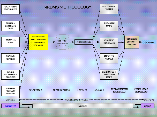
NRDMS programme aims to analyze the evolution of methodologies and techniques for formulating development strategies. In a scenario of large diversity of data sets, data users and data generating agencies, the programme aims at developing and demonstrating the use of spatial decision support tools for integrated planning and management of resources at the local level. The NRDMS programme uses both maps and textual data collected from various data generating agencies and remote sensing sources. Maps are digitized and stored on a computer as a series of thematic data layers. Depending on the real unit of planning, maps on 1:250,000, 1:50,000 and cadastral scales are utilized. Data on natural resources, demography, agro & socio-economy and infrastructural facilities for a district form the core database. Those pertaining to specific problems of an area constitute the sectoral database. Textual data obtained from secondary sources are normally stored with village as a unit. Data gaps are filled in by limited primary surveys. Various decision support systems \ modules built into the system help process the data and generate alternative scenarios for making optimal planning decisions. Outputs in the form of thematic maps, tables and reports based on spatial analysis are obtained from the database as per the user requirements.

The diagram below indicates broadly the methodology adopted in the NRDMS project.
Go Top

Geographical Information System [GIS]

A geographic information system (GIS), captures, stores, analyzes, manages, and presents data that is linked to location. Technically, GIS is geographic information systems which includes mapping software and its application with remote sensing, land surveying, aerial photography, geo-positioning system, mathematics, photogrammetry, geography, and tools that can be implemented with GIS software. GIS applications are tools that allow users to create interactive queries (user created searches), analyze spatial information, edit data, maps, and present the results of all these operations.

GIS have taken advantage of rapid developments in Information technology over the past several decades to address the spatial challenges of storing and analyzing spatial data. GIS belongs to the class of computer systems that require the building of large databases before they actually become useful. Actually, the use of a GIS requires that large spatial database be created, appropriate hardware / software be procured and installed, applications be developed, installed, integrated and tested before users can use the GIS and realize the benefit.

The role of a GIS in a government setup is more than simply automating a few obvious tasks for the sake of efficiency. A local government or zilla panchayath should view the GIS project as an opportunity to introduce fundamental change into the way its business is conducted. Just as MIS / EIS in corporate business world, the adoption of GIS effectively reorganises the data and information that the government collects, maintains and uses to conduct its affairs. This will lead to major changes in the institution both effectiveness and efficiency of operations. NRDMS uses corporate database concept to integrate GIS data for all units of Zilla Panchayath participating in a co-operative GIS program. Establishing the corporate database is much more a question of policy, management co-operation and co-ordination.

An effective corporate database does require co-operation on the part of all users, both for collection and entry of data in the database and in developing applications in a shared data context. This may result in some individual applications or uses being less efficient, however the overall benefits to the organization can easily out weigh these inefficiencies. Greater emphasis must be placed on maintaining a high quality of data and services to users.

Go Top

District NRDMS centres and their year of Establishment


Sl.
No.

NRDMS Centres

Year of Establishment

1.

Vijayapura (Bijapur)

1993-1994

2. 

Dakshina Kannada

1992-1993

3.

Dharwad

1992-1993

4.

Mysore

1992-1993

5.

Kalaburagi (Gulbarga)

1993-1994

6.

Uttara Kannada

1993-1994

7.

Belagavi (Belgaum)

1994-1995

8.

Hassan

1994-1995

9.

Kolar

1994-1995

10.

Shivamogga (Shimoga)

1994-1995

11.

Bangalore Rural

1996-1997

12.

Raichur

1997-1998

13.

Tumkur

1997-1998

14.

Bellary

2001-2002

15.

Mandya

2001-2002

16.

Kodagu (Coorg)

2001-2002

17.

Bangalore Urban

2006-2007

18.

Bidar

2006-2007

19.

Chikmagalur

2006-2007

20.

Chitradurga

2006-2007

21.

Bagalkote

2007-2008

22.

Gadag

2007-2008

23.

Haveri

2007-2008

24.

Koppal

2007-2008

25.

Davangere

2007-2008

26.

Udupi

2007-2008

27.

Chamarajanagara

2007-2008

28.

Chikballapura

2008-2009

29.

Ramanagara

2008-2009

30.

Yadgir

2009-2010

31.

Vijayanagara

2021-2022

Go Top


Geospatial database
generated by District NRDMS centres on 1:50,000

Taluk Level Data

1. Boundaries

  • Gram Panchayath Boundary

  • Hobli Boundary

  • Taluk Panchayath Boundary

  • Zilla Panchayath Boundary

  • Village Boundary

2. Headquarters

  • Gram Panchayath Headquarters

  • Hobli Headquarters

  • Taluk Panchayath Headquarters

3. Settlements

4. Facilities

  • Bank Facilities

  • Communication Facilities

  • Credit Societies Facilities

  • Drinking Water Facilities

  • Educational Facilities

  • Medical Facilities

  • Post And Telegraph Facilities

  • Recreational And Cultural Facilities etc.

District Level Data

5. Boundaries

  • Gram Panchayath Boundary

  • Hobli Boundary

  • Taluk Panchayath Boundary

  • Zilla Panchayath Boundary

  • Village Boundary

6. Headquarters

  • Gram Panchayath Headquarters

  • Hobli Headquarters

7. Settlements

8. Facilities

  • Communication Facilities

  • Credit Societies Facilities

  • Drinking Water Facilities

  • Educational Facilities

  • Medical Facilities

  • Post And Telegraph Facilities

  • Recreational And Cultural Facilities, etc.

State Level Data

  • Agro-Climatic Zones

  • Taluk/District Boundary

  • District Head Quarters

  • Division Boundary

  • Division Head Quarters

  • Geology

  • Meteorological Station

  • Parliamentary Constituencies

  • Legislative Assembly Constituencies

  • Rail network

  • Reservoir

  • Rain gauge Station

  • River

  • Drainage

  • Basin Boundary

  • Catchment Boundary

  • Sub catchment Boundary

  • Subdivision Boundary

  • Sub watershed Boundary

  • Tanks

  • National Highway

  • State Highway

  • Major district road

  • Other District Roads

  • Village roads

  • Airport etc.,

Non spatial Database (linked to village maps)

2001 Census Data (part I and part II)

Samanya Mahiti data - 21 sectors -357 fields (Infrastructure & Developmental activities Habitation wise) - Part of the data will be integrated.

Line department data

Themes for Attribute Data:

  • Groundwater (quality, depth to water table) 

  • Climate (pressure, temperature, humidity, rainfall)

  • Demography (population, literacy & levels of education, occupation)

  • Socioeconomic (industry, developmental activity)

  • Agro-economy (land utilisation, land ownership pattern, area under principal crops, irrigation, agricultural implements, animal husbandry)

  • Infrastructure (communication, drinking water, educational facility, electricity, financial institutions, markets, medical facilities & public health, transport, veterinary services etc.)

  • Miscellaneous recreation & tourism etc.

First Decade (1992-2002)

At the local level, necessary institutional changes were brought about during this period to ensure people's participation in the planning process. As per the provisions of the 73rd and 74th constitutional amendments, different State Governments constituted a three tier system of local bodies at district (Zilla Panchayath), block (Panchayath Samiti) and village (Gram Sabha) levels at rural areas and Municipalities (Nagarpalikas) at urban areas. Mandates of such local level bodies are to collect revenues, draw up and implement integrated development schemes. The VIII 5 Year- Plan (1990-95) of Planning Commission suggested that the developmental plans should be drawn up at the local level (district and below) taking into account the physical and human endowments of the area, felt needs of the people and funds available .Entry of GIS in India during late 80's and launching of Indian Remote Sensing Satellite during 1987 guided the evolution of the NRDMS programme during this decade. The programme was looked upon as a major initiative for introduction of Geospatial technologies and tools in the local level planning of the State.

In this context, the goals were focused towards :

  1. Development of spatial data management technologies for integrated rural development planning and

  2. Demonstration of utility of spatial data tools in local level decision making. Adoption of Geographical Information System (GIS) as the core of NRDMS methodology for locale specific problem solving was made explicit. Forging linkages with users at different levels was introduced as one of the objectives for dissemination of NRDMS methodology.

Go Top

Major Outputs of the NRDMS programme in the first decade (1992- 2002)

  1. Improved procedures for data collection, collation and processing at local level developed.

  2. Indigenous GIS package GRAM extensively used for customization and application development.

  3. Spatial Decision Support Systems for health, education, watershed, tourism and infrastructure developed.

  4. User- friendly interfaces developed for language conversion, visualization and spatial applications.

  5. Spatial district resource profiles and user specified applications developed and demonstrated at district level in selected sectors of infrastructure location/management, health, natural resource management, election management etc.

  6. Seventeen district NRDMS centre established.

  7. Availability of the Core Expertise in Spatial Data Management in Panchayath Raj Institutions/Districts / State.

Go Top


Major Applications:

  • Location/allocation of health facilities : The purpose of this application is to locate existing health facilities and indicate up-gradation / new location of medical facilities as per the health department norms.

  • Education Management and Information System : The purpose of this application is to locate existing educational facilities in the district and to indicate upgradation / location of new education centres as per the norms of the education department.

  • Tourism information system : This is to provide the information for the tourist and to help the decision makers to improve the infrastructure facilities in the districts to promote tourism development.


Go Top


Other Applications

  Administrative support district administration during emergencies

  Infrastructure location/allocation

  Disaster management system

  Flood affected villages & location of flood relief centers

  Election information system for general & local bodies

  Education Information system

  Health Information system

  Gram Panchayath information system

  Prioritization of Rural water supply for augmentation

  Rejuvenation of MI Tanks

  Prioritization of watershed

  Drinking water quality maps & Fluoride affected areas

  Tourism information system

  Village Assets Information System

  Police information system

  District resource and infrastructure profiles etc.


Go Top


Click on the above links for details...


Go Top


End User Interactions:

In each district there are several line departments, which are responsible for implementing the various schemes and programmes of the State and Central Government. These departments come under the direct control of Zilla Panchayath and the Deputy Commissioner office. The planning is done at the Zilla Panchayath level and also in some cases Deputy Commissioners level. Lot of information is required in planning an activity. Hence the NRDMS district centers are assisting the planning and executing bodies in providing these information and also help them in preparing their plans using GIS based technology. In this connection several workshops and training programmes have organized by the NRDMS centers to create an awareness of GIS technologies. The Council conducted user level workshops in all the districts of the State in the year 2007 - 08 to create awareness among end users in the utilisation of geospatial technologies in planning.


Divisional Level Training Program on
 "Application of Remote Sensing and GIS for Governance"


Geospatial Excellence Award for the year 2014

Karnataka State Spatial Data Infrastructure (KSSDI) was awarded Geospatial Excellence Award for the year 2014 for establishing a citizen centric KSSDI portal and for effectively disseminating geospatial information to all users. This was awarded at India Geospatial Forum 2015 event held on 10th February 2015 at Hyderabad.

Dr. Shailesh Nayak, Secretary, Ministry of Earth Sciences, Government of India gave away the Certificate and memento to Shri H. Hemanth Kumar, Principal Investigator, KSSDI Programme & Dr. M. Prithviraj, Executive Secretary, Karnataka State Council for Science and Technology (KSCST). The award is given to KSCST and DST-GOI.


Report on National level Workshop On "Geospatial Technologies and its Application"

21st September, 2015 - 9th October, 2015


Go Top


Location of district NRDMS centres and
officers responsible for those districts


Go Top


Contact us

Mr. Anil R. Naik

Principal Investigator - NRDMS

Karnataka State Council for Science and Technology

Indian Institute of Science Campus, Bangalore - 560 012

Phone: 080 23341652, 23314396

E-mail: anilrnaik.kscst@ka.gov.in, anilrnaik@kscst.org.in


Activities of District NRDMS Centers:


View maps generated by District NRDMS Centers


Access and discovery of spatial data through web. Click here to access this portal...


Close Window


Go Top


This page was updated on : 13 March, 2024 02:46:06 PM

  Copyright KSCST. All Rights Reserved