Basics of RWH || RWH from Rooftop || RWH Illustrations || Ground Water Recharge || RWH - Roads, Parks, Layouts
|
Rainwater Harvesting (RWH) |
|
|
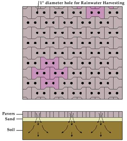
Rainwater Harvesting from Roads In the recent past, rapid growth in the urban areas has led to asphalted roads and stone slabs or pavers for footpaths. This accounts for nearly 10% of the total area of Bangalore. Consequent to this, the rainwater run-off has increased and ground water recharge has declined. As the roads are built sloped towards the sides, rainwater falling on the road is guided to the side drains. When it rains, water flows from the apex to the sides and collects in the sidewalk area and subsequently flows to the storm water drains. To increase ground water recharge by percolation and decrease the flooding of storm water drains, an infiltration trench could be built by the side of the drain all along the road, wherever possible. The infiltration trench can be 2 feet wide and 2 feet deep and filled with pebbles or aggregates with a top layer of coarse river sand. As the rainwater from the road flows into the infiltration trench, water percolates into the ground. During heavy rainfall, excess water spills over to the storm water drains. The infiltration trenches store water temporarily during rainfall and later for infiltration. These infiltration trenches may be exposed as walk ways or paved with inter-locking pavers, specially designed with gaps in between for water to flow into the infiltration trenches.
Parks and Open Spaces Water harvesting methods in parks and open spaces involve micro-watershed management methods that allow rainwater infiltration and percolation into the ground. The runoff has to be minimized by providing adequate number of percolation pits and dispersion trenches. In large parks, storage of rainwater in small ponds is also possible since the ponds can be integrated with the landscape of the park. Mapping of the contours, planning for rainwater outflow in consonance with natural drainage patterns, identifying appropriate areas for percolation pits / dispersion trenches will be required. Recharge of pits or trenches Ground water recharge in parks can be enhanced by a simple technique of providing recharge pits or a trench.
RequirementsCreation of water harvesting ponds in concave depression and low-lying areas. · Allowing groundwater recharge by the creation of seepage pits.· Allowing surface runoff to enter into existing wells or artificial water bodies.Natural flow of water
Rainwater run-off from open space and paved areas can be stored in underground sumps by filtering through sand-bed filters and guiding the filtered water through channels. Layouts Layout refers to a geographical area encompassing sites, roads, drains, civil amenities and parks. Rainwater Harvesting in layouts can be done using the 'Cascade Capture Method'. In this process, rainwater can be harvested on a plot or through recharge of ground water. The run-off from the plot could be captured by storm water drains and directed into artificial infiltration or percolation pits. The overflow from the storm water drains and infiltration system could be captured in lakes and tanks. The method of rainwater harvesting involves contour mapping, drainage pattern, determining a storage point / ground water recharge and ensuring segregation of sewage / sullage from storm water run-off.
|
|
|
|
|
| This page was updated on : 08/31/2020 04:30:36 PM +0530 | |
| Copyright 2006, All Rights Reserved | |
afddf